We hiked this section in May of 2015.
“Those who don’t believe in magic, will never find it.” -Roald Dahl
After a nine and a half hour drive, we arrive at the Motel 6 in Mojave, the hikers' choice outside of town, not to be confused with the one in town. We called them previously and they had generously offered to let our car be parked there until we got back from hiking. For free. It is a very clean and spartan establishment. And cheap. We totally recommend it for beginning California section F of the PCT.
We start double checking our backpacking gear, even though it is 10 pm, and realize that we forgot to get propane. I vaguely remember the one item on our REI list that I couldn't read, it must have been propane. Oops. It looks like we would have to delay our start on the PCT in the morning, as a trip back into Tehachapi would be required. We then decide to ditch some of our gear: flip flops and a few other non essentials go back in the car, as this next section of the trail will require longer water hauls. I have trouble sleeping as excitement to be back on the trail keeps me awake. The trains blowing their whistles don't help either.

Day 1: Highway 58 to Golden Oak Springs (16.8 miles)
In the morning we make phone calls trying to find the right number for the bus that runs between Mojave and Tehachapi, as online sources state they would give us a ride to the trail. We keep getting put on hold and then getting disconnected, so we never do get a definitive answer. Providentially we meet Jetta Blue, a trail angel, who offers to give us a ride and she also has propane for sale. Yes. She has a sign up sheet for rides in the lobby of the motel and while it appeared to be full, she fits us in with Silver and Dream Time. It is nice talking with them as they have lots of experience on long trails and they are older like us. They get out of the car at Willow Springs Road, and she takes us to Highway 58 and Cameron Road. The beginning of Section F.
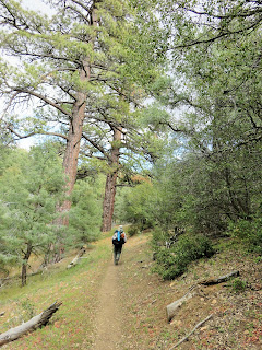
It's really windy and cold and she suggests we wait a day, as the winds on the upper ridges can gust up to 70 miles an hour, she says. We really feel led to begin, and know we can just turn back if it doesn't work out, so she drops us off and we begin. It is a mile walk alongside the highway and then we begin climbing into the nothingness of the clouds. It's a bit surreal and we feel like we have just departed the trail, although over a year has gone by since our last big section hike. There is something special about this ribbon of brown that stretches from Mexico to Canada and whenever we get on it we feel its charisma and onward pull.


Once we reach the top of the ridge we are swept along to the other side and the winds lessen. We see our first blooming yucca and meet some thru hikers along the way as well as 3 men on dirt bikes. We arrive at Golden Oak Springs after about 8 hours walking. We feel good, no blisters, no pain. Just a bit tired from a day of walking. We still have water and realize that the cool conditions didn't warrant carrying that much. The area around the spring is quite crowded with tents so we move up the hill. All night long we hear the hum of the wind turbines and feel the icy, wet fingers of the wind as it keeps finding its way into our tent.
____________________________________________________
Day 2: Golden Oaks Springs to Robin Bird Springs (19 miles)

We are greeted by cows when we poke our heads out of the tent in the morning. Well, hello there. They too need to gather at the springs and we had apparently camped in their home turf. Good thing they were friendly cows. I will say that the biggest one did eye my pro bar breakfast with a bit of a hungry gleam, but I wasn't about to share. We refilled up our water carriers, packed up our gear and hit the trail.

It's another cool and cloudy day, just right for hiking. We start off by meandering through a forest with the steady hum of the wind turbines. They are everywhere, but I somehow neglect to get a good photo of them. It might have been a subconscious thing; if I don't look then they aren't there. I think that it is great that we are making alternative energy, but at times the noise of them is over powering.

All too soon we enter a burned area. We are glad that it is cool as there is no shade in sight. Flowers brighten the way. At one point we pass a couple in a tent, without their rainfly, enjoying a moment of sunshine and some, um, couple gymnastics. You never know just what you might see on this trail.

Lunch with a view and then...


Soon after we pass the PCT 600 mile mark we arrived at Robin Bird Springs, our destination for the night. Again, hikers are gathered around. This night most of them hike on a bit further. Do we stink? We find a campsite in an old foundation of a cabin. Liz, a NBC news reporter from Oklahoma and Kevin from Maryland camp next to us. They are a friendly pair.
___________________________________________________
Day 3: Robin Bird Spring to a few miles past Willow Springs (22 miles)

Bee Martins, Robins, Finches,
Singing morning
Quiet, Still.
No wind?
Yes. Warm. Yes.
Beautiful day for hiking and we realize why this spring was thus named. The song from the various birds is wonderful. A new day has dawned and we find ourselves in a magical forest. No wind, green grass, green trees and granite rocks. Did we get moved in the night by little mythical men? It is wonderful hiking without the wind blasting us. We hadn't realized how much it was bugging us. And the colors along the way are so much prettier with a little light shining.


We stop for lunch at about 11 am at Landers Spring. A really nice place to take a break. There are rumors that the next water source, Willow Springs, is capped. Whatever that means. And the last PCT water report noted that there was a dead raven in the water trough and a dead rat in the cistern. Most hikers are deciding to bypass Willow Springs. We have decisions to make. If we don't use Willow Springs for water then we would be carrying from Landers Spring all the way to Walker Pass, about 42 miles. There was one possible spring available in between, Yellow Jacket Spring, but we don't have any information as to its present state. We decide to carry 12 liters between us and go for a dinner of snacks that don't require water and try to make a big push to Walker by tomorrow night. We are feeling pretty fantastic right then and 42 miles somehow seemed like a walk in the park and we had been carrying too much water anyway. Right? Who needs a liter of water for every 5 miles, we sure haven't.
We dry our gear out and take a bit of a rest and then headed back on the trail at 2 pm. Long break. Perhaps too long.

We soon enter more burned out forest. So sad. Clouds roll in and cool things down. Our spirits are high flying while our packs are cutting into our shoulders with all that water weight.

The fragrance of lupine fills the air and there are lots of other wildflowers in this burned out place.

Then forest again, but of a dryer sort then earlier in the day. It is really exciting to walk from one type of terrain to another within a day. We really see the country with fresh eyes.

We find a surprise at Kelso Road. Some trail angel has left gallons and gallons of water. In past years you could count on a few of these water caches in the desert, but this year, everyone was warned that there are too many hikers and trail angels don't want the responsibility of having to have water there. We did not count on any water caches, but are real happy to find one. We decide to make a real dinner before heading on and we also top off our 6 liters again. Yes. We love to carry heavy loads. Oh yes we do. We are feeling invincible at this point for some reason.

We hike on as shadows grow long. We see Willow Springs down below at one point and realize that it would have been a good idea to at least have checked there as it really isn't out of the way at all and probably had fine water. Who cares about a little rat.

It is a desert scape we are in again, as the forest has departed, or maybe the morning forest was but a mirage, and we are climbing with heavy packs and on a sandy trail, but it feels so good to be alive and here at this point in time. We are loving it.

The sun sets and a small moon rises. The sandy trail glows and we hike on. The wind picks up, but I'm not cold. We are both grinning ear to ear. Endorphins are really kicking in. We say hi to those already camping. They ask us where we are going and we say we are going further. We don't have a real destination in mind, but we both feel fine under a tapestry of stars along this winding path. We hike some more and a bit more and around a bend the wind is blocked. We find a flat spot and make camp and sleep.
____________________________________________________
Day 4: Somewhere to Somewhere (Tj: 20 miles/ Mark 21.4)

We awake at 5, but try to sleep more. At 6 we are drinking a bit of coffee when Karaoke comes by singing, ‘Morning Has Broken
‘ and you know it is a good one if you are awake to see this early hiker. We've been leap frogging her and her sister and Juniper from Canada, since we started our hike. They seem like sweet, wholesome young women and we enjoy their company.

Mark gentles a wild camel and talks it in to carrying our packs. Wow. It really helps because the trail is deep sand, like at the beach. I imagine for while that I am at the beach and just over that next dune I can jump in the water.

Or maybe our plane crashed and we are the only survivors or we are taking in much needed medical supplies to a remote village. I must climb this mountain, the people need me. These are the little mind games I play as we hike. I hear the cheering fans, I smell the victory. I am not sure what Mark does in his mind. I think he often does mathematical things like figuring out how many miles to here or there and how many steps it takes and other such thing. But I don't really know. We both enjoy walking, obviously, and nature and the challenge of backpacking and the sometimes shared conversation, but on this day we are both a bit quiet. It is getting warm for the first time and we have a really big climb coming up and I wonder if we have enough water and can we hike the 27 miles to Walker Pass? We've hiked 26 miles before and Mark's ran a marathon, but we've never hiked 27 miles in the heat with a heavy pack.


Somewhere on the climb, looking back from where we came. Did I mention it is getting hot.


We hike on and on, or so it seems to me, and eventually I run out of energy. I begin to not believe that I can hike 27 miles on this hot day. I begin to believe that I don't have enough water. I begin to want to take a nap. Mark is not tired. He is like the energizer bunny. He rescues me and takes the tent poles. He plies me with jolly ranchers, but eventually gives up when we reach the junction with the Yellow Jacket Spring. We decide that I will rest while he hikes the .7 miles down to the spring. He will bring up water if it is available and we can get more water and share with others who are behind us. I drink and eat and sit in the shade of a lovely oak. Soon others gather round me.


Mark finds water and it is very sweet and so is he for fetching it.
We hike on. My stomach starts doing and saying funny things and I have to keep going into the woods to dig a hole. It slows us down. I have to unbuckle my waist strap and my shoulders begin screaming out in pain. I buckle my waist belt and then my stomach starts doing the tango again. I give up. We throw up our tent somewhere in a burned out area and Mark makes me some plain rice and I eat it and a few saltines and fall asleep. Mark has to be a bit disappointed because he really wanted to make some big miles today and he was full of the energy to do it, but I just couldn't find the will to do it. We are a couple through thick and thin.
______________________________________________

It is all downhill to Walker Pass and I am feeling fine. We meet a couple of older gentlemen wearing polos and little daypacks full of payday candy bars. Trail magic. They are excited to see us and give us a candy bar. They want to know if there are more hikers behind us and I assure them that there are. There eyes get all twinkly, especially the older man who is tiny and looks a bit like an old woman on chemo. He has his friend pull out more candy bars from his pack so he will be ready. Such good cheer they have.


Mark gentles a wild camel and talks it in to carrying our packs. Wow. It really helps because the trail is deep sand, like at the beach. I imagine for while that I am at the beach and just over that next dune I can jump in the water.

Or maybe our plane crashed and we are the only survivors or we are taking in much needed medical supplies to a remote village. I must climb this mountain, the people need me. These are the little mind games I play as we hike. I hear the cheering fans, I smell the victory. I am not sure what Mark does in his mind. I think he often does mathematical things like figuring out how many miles to here or there and how many steps it takes and other such thing. But I don't really know. We both enjoy walking, obviously, and nature and the challenge of backpacking and the sometimes shared conversation, but on this day we are both a bit quiet. It is getting warm for the first time and we have a really big climb coming up and I wonder if we have enough water and can we hike the 27 miles to Walker Pass? We've hiked 26 miles before and Mark's ran a marathon, but we've never hiked 27 miles in the heat with a heavy pack.

We get to Bird Song Pass and the water cache there is empty. We weren't counting on it, but realize it would have been nice to have a bit more water. We both have a little under 4 liters by 11am. We chit chat with Snow White and Wall Street, no I'm not hallucinating. Thru hikers on the trail take on trail names. Even though we are just section hikers we have been given names as well. Our trail names are 'Not Uncle Bob' and 'Pearl'. A case of mistaken identity for Mark's name and a penchant for wearing pearls for mine. Now for our climb. It is up and about 3000 feet and it is hot, but a breeze does pick up as we near the top. My heart pounds in my head and I only take a few drinks of water. I must conserve my water, I think as I climb.

Somewhere on the climb, looking back from where we came. Did I mention it is getting hot.

Once we reach the top of the ridge we see the white capped High Sierra. This is where we are going. Incredible. We are going to hike all that way! Such an exciting moment. It is momentous. But did I mention it is getting really hot?

We hike on and on, or so it seems to me, and eventually I run out of energy. I begin to not believe that I can hike 27 miles on this hot day. I begin to believe that I don't have enough water. I begin to want to take a nap. Mark is not tired. He is like the energizer bunny. He rescues me and takes the tent poles. He plies me with jolly ranchers, but eventually gives up when we reach the junction with the Yellow Jacket Spring. We decide that I will rest while he hikes the .7 miles down to the spring. He will bring up water if it is available and we can get more water and share with others who are behind us. I drink and eat and sit in the shade of a lovely oak. Soon others gather round me.


Mark finds water and it is very sweet and so is he for fetching it.

We hike on. My stomach starts doing and saying funny things and I have to keep going into the woods to dig a hole. It slows us down. I have to unbuckle my waist strap and my shoulders begin screaming out in pain. I buckle my waist belt and then my stomach starts doing the tango again. I give up. We throw up our tent somewhere in a burned out area and Mark makes me some plain rice and I eat it and a few saltines and fall asleep. Mark has to be a bit disappointed because he really wanted to make some big miles today and he was full of the energy to do it, but I just couldn't find the will to do it. We are a couple through thick and thin.
______________________________________________
Day 5: Somewhere to Walker Pass (7 miles)

It is all downhill to Walker Pass and I am feeling fine. We meet a couple of older gentlemen wearing polos and little daypacks full of payday candy bars. Trail magic. They are excited to see us and give us a candy bar. They want to know if there are more hikers behind us and I assure them that there are. There eyes get all twinkly, especially the older man who is tiny and looks a bit like an old woman on chemo. He has his friend pull out more candy bars from his pack so he will be ready. Such good cheer they have.
It is a beautiful day and we make it to Walker while the morning is still young and we dry out our gear and refill our water and a trail angel there, another retired man, gives me the REALLY short ride to the cistern so I can wash the clothes I soiled on my afternoon hike with a gastronomical issue. He is driving to Lake Isabella and is insistent that he give me a ride to the cistern. He gives another hiker a ride all the way to Lake Isabella. He offers it to us too, but we will soon be moving on down, or in this case, up the trail. More hikers pour in, and soon the whole area looks like a flea market or a yard sale with gear scattered around. We like it. It is fun being part of a larger community of hikers and we often think about the time we will embark on a thru hike of our own. For now though, we are enjoying our time as section hikers.
Slideshow of our hike of PCT California Section F:
Slideshow of our hike of PCT California Section F:
Lovin' it.
ReplyDeleteThanks very much for this! I plan to hike Section F in early May and your account is very helpful.
ReplyDelete