“The main facts in human life are five: birth, FOOD, sleep, love, and death.”- E.M. Forster
(Emphasis mine)
Walker Pass to about a mile past Joshua Tree Springs
About 13 miles
About 13 miles

We leave Walker Pass at 11 am and enter the Owens Peak Segment. We have a big climb and it is getting hot, so we are a bit worried that we tarried too long at the campground. We have already hiked 7 miles to get to Walker Pass today and are planning to go to the next water source, Joshua Tree Springs, for our evening camping spot.

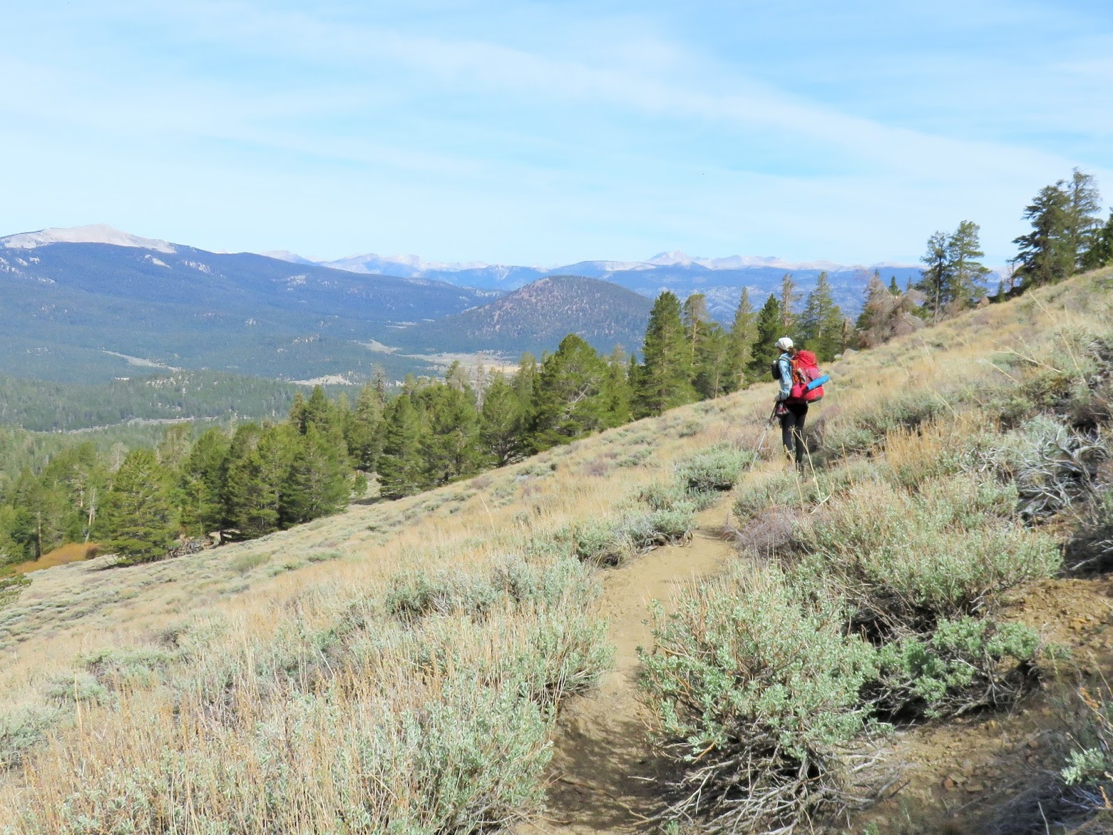
It is a barren place and a sandy trail, luckily it is graded very well and that makes the climb easier. There is also a cooling breeze as we hike higher.

This is view looking back down from about half way up. Note the switchbacks.


We learned that this flower is quite rare and should never be picked. It is a Charlotte's phacelia and the vivid deep-blue color is hard to miss. We also learn that the peak we are on was named after Jim Jenkins who before his death at age 27 had hiked all of the trails in the Southern Sierra and was the author of 2 books that name and map everything, and I mean everything (trails, water, history, flora and fauna) in the Southern Sierras. He was also consulted for finding trail routings for the PCT in the Southern Sierra. All before age 27. Wow.

We walk along a trail that clings to the side of Jenkins Peak. To the east the land drops away and there are large green circles in a sea of brown. Alfalfa we presume. The shale foot path eventually makes our feet sore and Mark gets a little blister and stops to cover it with tape. I begin to experience pain in my left shin that feels a lot like shin splints. I'm alarmed as I haven't had them since high school when I over strided trying to keep up with the long legged, fast girls in gym class. Shin splints could really ruin our hike.

The trail eventually heads west around the mountain, after lots of dizzying views to the east side. I keep thinking it would be a terrible place to be in an earthquake. We walk through an area where the ground is covered in little white forget me knots and the smell is incredibly good and then quickly becomes sickly sweet. We make it to Joshua Tree Springs and have the place all to ourselves, so we get in an argument of some sort. Probably about food. Either we are carrying too much or too little, or maybe I am carrying too much or too little. Grumpy we are. I think he is more grumpy, he thinks I am. Ha. I soak my leg in the trough as the pain has intensified and the area is swelling. I then remember that while hiking I had felt a bite or poke of some sort and I must not have shin splints after all, but just a little sting of some sort. I am relieved.
Mark makes dinner at the spring and we eat with flies and mosquitos buzzing. It is thick with insects. We're still mad and sit resolutely shoveling food and possibly insects into our mouths as other hikers show up. After eating we take off again for a camping spot further along the trail.

About a mile past Joshua Tree Spring we come to a little saddle and find a lovely camping spot and get treated to a great sunset. We make up and fall asleep.
_______________________________________________
A Mile Past the Joshua Tree Springs to Two Miles Past Fox Mill Springs
20 miles

Slept under stars and moon and awake to sunny, but hazy skies. AKA: Gonna be hot! We get up and hit the trail early for the water at Spanish Needle Creek, only a few miles away.

There we meet a Canadian couple and another young hiker who tells me she is almost out of food. Of course, I reach into my pack and give her a meal. We are almost a full day ahead of schedule and have extra food. Mark is up the hill getting the water and unfortunately when he gets back we get in another little spat about it. I should have asked him first, since we share everything. Oops. I tell you, food is definitely becoming an issue. We grumpily carry our argument up the hill to a camp site and lay all of our gear out to dry. Mark makes some coffee and we talk it out while our stuff dries. Coffee helps and we soon regain a good mood and move on.

As we climb the trail gets prettier and there is once again a cool breeze.

Until we enter the Chimney Creek area, that is. Boy, does it get hot. We stop at about 2 pm and sit in the shade on some boulders and cool off. The Appster figures out stuff while we wait and reads aloud about the Chimney Creek area. I eat a lot. Maybe I do eat more than I carry. Hmmm? More food issues. Ha.

We hike on down to the actual creek of Chimney Creek and find a nice, albeit little, pool for cooling off and getting a bit more water. A few other hikers are here as well.

As we head up the trail to our next water source, Fox Mill Spring, Mark begins seeing lots of obsidian flakes. In some areas the ground is littered with the tell tale sign that a native American once sat there making arrowheads.

Fox Mill Spring also has a lot of historic old stuff. Mark picks up an old piece of shaped wood and asks me what it might be. All of a sudden I have a vision of a house with shutters. So weird. It's a shutter, I tell him, as a little shiver runs up my spine.

We cook our dinner at the springs and load up our water. I tell Mark our next water is in 10 miles, so we both just take a couple of liters for the night and for our hike in the morning. We head up the trail a few miles to a nice private spot with a view. Once we reach camp and unload our packs, Mark discovers he only has a liter and a half of water (he didn't take his platypus out of his pack when he filled it) and that the water 8 miles away might not be there as the water report says it is dry. Quite a few times though, the water report has said dry and we find water, so the source is a bit questionable. I have 2 and a half liters, so we would still each have 2 liters. It should be fine. We decide to just sleep on it and make a decision about whether to go back for water in the morning. Our biggest worries seem to be water and food.
______________________________________________
2 Miles above Fox Mill Spring to Kennedy Meadows Store
17.8 miles for Tj and 21.8 for Mark
Mark awakes at 4:30 am and wants to start hiking, I took a half of flexeril last night for my jittery, aching legs and don't want to be roused. He decides to just get up and go back the 2 miles to the spring and fetch more water. I sleep on and awake when the sun's glow peeks over the mountain.

Mark soon arrives and we have coffee and eat our probar breakfast while we pack up our stuff and somehow get into another argument. Geez. We usually are happiest hiking, but the last few days have been a big disappointment on that front.

It is also disappointing to walk into another burned area. Our trail 'therapy' session heats up and we continue discussing things quite loudly. Our argument shifts into real life stuff, bigger stuff than trail food and water and tears pool up and run down my cheeks. It is a bit embarrassing when another hiker passes us. Later an older woman suddenly comes around the bend toward us and I see her kind and knowing smile and somehow it makes our disagreement feel more normal. We continue our conversation in a more adult fashion and actually begin listening to each other.

We are hiking fast, for us, today, 3.5 miles per hour. The anger and a downhill trail I suppose. At one point a humongous rattle snake slithers quickly across the trail and coils up in a bush and rattles like crazy at us. Mark wants the camera, but I am already many yards away and don't give it to him. It was about 3 feet in length and 3 inches thick with about 3 inches of rattles.

This area is called Domelands or "Rocks" and there was water at Manter Creek. Mark went back for our peace of mind though and he always wants to hike more miles, so we aren't upset about it. Better safe than sorry is our motto, most days.

When we get to the Kern River we take a swim in a beaver pond. It is fun and the clouds overhead playful and we cool off. All is well in our world once again.

We hike on after an hour or more and soon come to the PCT 700 mile mark.

And we hike and hike across a long, dry area and it is hot and we know we are close to Kennedy Meadows store and all kinds of food and drink await. I hike faster and faster and faster and we see a car up ahead on a road and two other hikers in front of us go to the car. Could it be trail magic? It is. We get chips and soda from Burk and it is good. We hike on the road .8 miles to the store.

It is about 2 pm and we order from the grill and have beers and Gatorade and enjoy visiting with the Canadian couple again. They've been hiking mostly 30 mile days since Campo. Pretty impressive. The crowd begins to feel oppressive to me and we go and shower (after a really long wait) and then buy food to resupply for our next section and nothing has prices and we spend too much and buy too much, so we get a couple more beers and order some pizza and then they give us ice cream and cake. We waiver back and forth back with our planning and put food in the hiker box and then decide we will need more and buy some Ramen, as of course some hiker grabbed the food we put in the box as soon as we put it down. It's ridiculous and I am overwhelmed by too many choices. We aren't sure what we are doing and then I mandate that we should each carry what we want to eat. No more arguing. If you go hungry, it will be your own fault, if you carry too much, it is your own doing as well. Mark buys a big bag of Fritos and says he won't share, smiling. I even go so far as splitting up our toothbrushes and first aid supplies and he gives me our Inreach device, as he has a phone. I guess I am still carrying a grudge, but it does kind of make sense and I don't want any more food arguments.
It is hot here and we just kind of use our sleeping bags as a cover and fall asleep as the sun is setting behind the mountains. Later I awake in the dark of night and hear people laughing and having a good time. I just look forward to being back on the trail tomorrow as we are headed into the High Sierra.
Kennedy Meadows to Spring at the top of Cow Creek
20 miles


Later we come through another burn and I don't want to take any more photos of burned out forest. It is too sad.

As we are leaving the burned out forest we see a meadow and meet a dozen or more high school seniors out hiking for their senior trip.
We skirt more meadows and soon come to the Kern River again. It's been an easy 9 mile hike so far today.

It looks like a park and we join other hikers lounging along its banks. Mark shares his Fritos and I feel like a heel for being so rigid yesterday. Swallows are nesting under the bridge and they fill the sky. We lay back in the grass and enjoy the day. The river is only a few inches deep, it should be roaring past right now, but there isn't much melting snow to fill it up. It is extremely dry for the end of May.

In the afternoon sometime, who knows what time as we are on trail time, we lazily hike on. Life is good.

Snow Flowers

Trees that are ALIVE!


Sunset has us camped on top of a little rise above the spring, with views. This is a view to the southwest. The meadows below are the ones the Kern River flows through and where we were just a few short hours ago. It is so awesome to travel by foot and feel the lay of the land and be a part of it like the animals that live there. There is something elemental about walking where you want to go that fills a basic need we seem to have. There is also the whole adventurer aspect to it that makes our hearts beat just a little faster and feels us with excitement for what might be just around the bend.

Here's our camp for the night. Our first night at almost 10,000 feet in elevation. I was fine hiking, but have a few moments of breathlessness, and a bit of panic, as my mind tries to regulate my breathing to my oxygen needs as I begin to rest. Take note of those poles laying on the ground and my clothes drying.
______________________________________________________
Spring to Diaz Creek
20 miles
We wake exhausted because of a rat. A wily, acrobatic, determined rat.I awake in the night and hear something. It takes me awhile, but I realize something is eating our hiking poles. I grab them and put them in the tent, and get the head light turned on and see a little rat with a short flat tail looking back at me. I yell at it and it scurries off. Mark wakes up. I explain the situation and we go back to sleep. The little bugger comes back. This time I hear it trying to get my clothes and I bring them in and then, later, it tries to eat our packs and then, later, it tries to get Mark's cup. The tent is now piled high with our gear and still the little rat won't leave us alone as he starts gnawing his way into the tent. I sit up and look down at him not 6 inches away from me. Mark says he would shoot him if he had a gun. I get an idea. Opening the zipper , of course he runs away, I grab a pole and hold it in the air waiting for him to return which he does within a couple of minutes. I wait and wait for just the right moment and then I whack him. I tell you it feels good, but I am glad I only whack a part of him, as he runs away and leaves us alone for what is left of the night. By this time it is the wee hours of the morning.

Here is Mark's pole with the strap chewed off. I suppose he was wanting the salt or maybe a trophy for his house. Who knows the reasoning of a rat. My poles have little teeth marks.
Just like in life, we don't let a little rat ruin our day so we enjoy our morning climb and the vistas that follow. There should be lots of snow, but we can only see a little on Olancha and a bit more on Langley.

Langley

Looking back at Olancha

Passing Marmot Meadow, I think it was called Gomez Meadows, we come to Death Canyon Creek. Sounds like a good place to get water. Right? We eat and I am tired from all of my adventures the night before so I take a nap while Mark gets the water and visits with all the people who pass by.
In the afternoon we continue and even with a bit of a climb, its a great day.

There are lots of awesome ancient trees,

and really fantastic rock formations.

And amazing views. This one is to the east side, looking down on Owen's Valley.


We meet Big UPs this way and our first impression of him is stellar. He is almost in tears of joy for finally being in the Sierra Mountains. He is floating on clouds. Big UPs is from Virginia and it is his first time here and it is exceeding his expectations. We really like this young man and enjoy our visit. There is something about him that speaks of good things. We wish we could get to know him more. One of the things we like about our PCT section hikes is the people we meet. People from all over the world.

We glowingly walk on to Diaz Creek. Along the way we talk about the next day's hike and we discover we are in agreement that we should not be law breakers. While we want to hike on, we don't want to get fined for not having a bear canister. We realize too, that it makes more sense to take the 1.8 mile detour at Mulkey Pass to get to Horseshoe Meadows and then on to Lone Pine than out Trails Crest by Whitney. But the best decision we make is that we are coming back into the Sierra in the fall and re-entering the trail at Mulkey Pass and hiking to Tuolumne. Yes! We both are happy at the prospect of coming back and hiking a few more weeks in our favorite area in the whole wide world. We go to sleep happy at our decision to return in August.
______________________________________________________
Diaz Creek to Lone Pine via Mulkey Pass Trail

We sleep in as it is only a short hike to the Mulkey Pass Detour. We're a bit melancholy to be leaving the mountains this morning, but it is another glorious day and we enjoy the trail we have left to hike. That is all any of us ever really have. Just this moment, so we grab it.

Just one week ago, we were here, in section F, looking at the snowy mountains.

Now we are HERE, in the snowy mountains. Amazing. Our four feet have carried us strongly all the way. We feel happy and so good. Satisfied even.

We get to Horseshoe Meadows well before noon and meet up with other hikers looking for a hitch. Big Ups is one of the hikers and we enjoy seeing him again.

A Samaritan loaded up all 7 of us stinky hikers and drove carefully the 22 miles down into Lone Pine.

Our trails end. 181 miles hiked in 9 days and a couple of hours.
The next day we catch the 395 bus headed south and get off in Mojave and walk a short distance back to our car at the Motel 6. Easy logistics for entering and exiting the PCT in this area.
Things we learned along the way:
We are stronger than we thought as we hiked ,back to back, 20 mile days without any problems. We can carry 6 liters of water each with only our shoulders getting sore. A scoop made out of a 20 oz. water bottle with the top cut off makes getting water easier. We don't need camp shoes or underarm deodorant. We can get into arguments on the trail and food is often the point of contention. It is a good idea for each of us to plan our own food and carry it. LOL.
Mark's addition: What I really learned is that Tj is going to eat whatever she is going to eat and I better just shut up and carry the damn food. LOL.
Mark's addition: What I really learned is that Tj is going to eat whatever she is going to eat and I better just shut up and carry the damn food. LOL.
Comments
Post a Comment
We love your comments or questions. Have a great day and live a good life.