Hwy 58 to Summit (mile 566 to 549)
"Like wildflowers; you must allow yourself to grow in all the places people thought you never would." -E.V.
Day 1:

Due to weather predictions and convenience we chose to hike this section southbound. We used the Motel 6 in Mojave the night before commencing and they allowed us to leave our car parked there. The Mojave chamber of commerce has connections to trail angels to give hikers a ride to the trail, and we used a kind man named Doug. (Don't forget to tip for gas).
-------------------------------------------
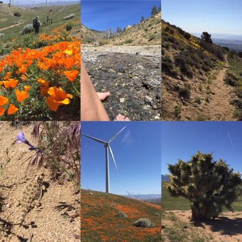
We begin hiking at 8:30 am and frost lay on the ground still. It is a beautiful spring day with only the slightest of breeze. We have a mile and a half road walk to get to the dirt trail. A train roars by, tooting its horn. It is a great day to begin an adventure.
We climb a bit and are surrounded by windmills and wildflowers for the next 6.5 miles. It is a pleasant hike over rolling green hills. We meet some day hikers enjoying the flowers.
We had left water at the Willow Springs/ Cameron Road junction the day before and we load up here for the 9 mile climb to the summit. We soon pass an odd picket fence off to the left and discover the grave of James Foley, 1841-1863. We wonder of his story and how it differs from ours. What did he do with his time? What are we doing with ours?
Passing a picnic table we stop for lunch and enjoy a huge burrito we carried from Anthony's Grill in Mojave. It is right across the street from the Motel 6 and we always stop when we are in the area. It’s good Mexican food and we lay in the sun a bit letting it digest.
We continue our hike and sweat begins to flow. It's a bit of a climb and it is warm. 2200 feet of elevation gain to the summit. Joshua trees enter the landscape and they are blooming. Blooming! It’s magic when they bloom. The Tehachapi mountain to the SW has a dusting of snow. Most of this area had burned over, so there are a quite a few fallen trees we have to navigate around as we make our way along the trail. Flowers abound and we have large sweeping views.
It's about 5:30 when we make 17 miles and the summit. We find a campsite next to Daniel and Larry's water cache. Thanks guys. We make a toast to them as we enjoy a drink of water and drop a bit into their donation can. We have enough carried water for a dinner of snacks, but with their water gift we cook a dinner. The sun sets and it is cold. Brr! Good thing our bags zip together.
The moon rises orange,
above the city shimmer
Far down below us.
Day 2:
Mile 549 to 534
15 miles
We awake at dawn feeling stiff and old so we go back to sleep. We start hiking at about 9 am through an apocalypse landscape, with blackened trees all in various stages of decay. Like us humans. Around a bend we begin descending in earnest through a flower lined path. The views are wide open and it is another good day.
We drop 2000 feet in 4 miles. Yesterday we climbed basically the same but we did it over 9 miles. We are glad we are hiking southbound and feel for the thru hikers who will soon be heading up this steep, shadeless section.
We hike about 500 feet out of the first canyon along a sand filled sloped trail. It's steep and our feet sometimes slide. Flowers still.
Down canyon then back up to cross a narrow draw. We do this numerous times and about midday descend into Tylerhorse Canyon. Water flows and we soak our feet and eat. It's very peaceful.
More canyons then a wind farm blanketed in poppies and daisies. It's basically downhill, flat walking and we make it to Cottonwood bridge by 5, with a bit of a breeze blowing at our backs. Some man driving by takes our picture. We get some water at the bridge (faucet dry, big bottle is full) and hike on a mile or so before finding a place to camp surrounded by bushes. The wind roars a bit above us, but it is nice and calm in our hidden camp.
Day 3:

Mile 534 to 517 (Hikertown)
17 miles
Sleeping at 4000 feet is a lot warmer than the 6000 foot elevation of the night before. We awake amazingly flexible and feeling good in stark contrast to yesterday morning.
Our trail today is the aqueduct road. A runner approaches us. She is running a marathon on the PCT today. Woohoo. She's got a climb. We walk on and on in a fairly flat landscape. A truck roars by. The birds sing, somebody is shooting their gun like 4000 times, and a slight breeze makes the hiking pleasant. It might be 65 degrees. We alternate between walking on concrete and the dirt road running alongside. I had envisioned the aqueduct as straight, but it is serpentine. I put away my walking sticks and wish our friend URL was here to sing to us. I play some hymns from my playlist instead. It elevates the day. The flowers start dancing in the wind with their faces pointed up to the heavens praising the creator.
By 2 pm we are showering at Hikertown hostel and eventually find our resupply package in the Post Office and find the curator, Bob, in the Jail. (It is a fake jail, in case you think literally!) He gives us the keys to his van and we drive down to the grill for a burger. Thanks Bob.
It's just us here tonight and we have the hiker lounge to ourselves. We've washed and dried our clothes and got our food situated for our next hiking leg.


Day 4:


Mile 517 to 502
15 miles
I blame our tiredness on the wind zombies that kept trying to bang down the garage doors of the hiker lounge/garage last night. With the weirdness of this place and all the wind noise, we didn't sleep well. Give me our tent any day over someone's garage and a lumpy couch.
We are currently laying about 10 feet from that concrete tank in the photo. We are inside our lovely tent with down bags piled all over us. The setting sun is outside our western facing door. It feels special tonight and maybe it is because we are on top of a mountain called Liebra. We sure feel free. Free Mountain. Free falling.
We left our couches at Hiker Town this morning at 7:30 am and headed across the prairie and up the hill beyond. Then down and then back up. We went west all morning. The trail overgrown in spots had us checking our gps app (Guthook) to make sure we were on the trail. The flowers made it worth it. Wow. Spectacular. As we climbed we could see down into the desert valley below and saw large areas of orange, yellow and purple. It looked like large paint splats dropped on the ground from heaven. The flowers were all around us too. It was heavenly. Lupines all together smell sweet.
Many more, long miles (to us) continued through mixed forest and oaken glen. At times we liked it and other times not. When we got to the guzzler we stopped.
A guzzler is really thrifty.


The metal roof catches the rain and then it flows to the gutter and then into a pipe into a big covered trough. One end is sloped for critters and the other has a removable lid for two legged critters to get a drink.
There are a lot of itty bitty critters in the water and quite a bit of woody debris as well. So we strain the water through a hanky. Then we filter it.

Day 5:


Mile 502 to 485
17 miles
"Blessed are the poor in spirit for theirs is the kingdom of heaven."
Easter Sunrise on top of the mountain after a magical, peaceful sleep. Amazingly there was no wind. Completely still.
Instead of searching for Easter eggs we look for hidden guzzlers and fire cisterns. We take communion on miner's lettuce. The trail always trending down through a mixed forest of fir, long leafed pine, cedar and oaks. Until the burn.
We missed our burn detour trail to Shake Campground. Where are the signs? Ending up at Maxwell camp we filtered a bit of green water from a guzzler and walked the Maxwell Truck Road through the closed off area. Oops. What devastation we witnessed from the fire and the crazy rain event last October. The trail IS off limits and the road was almost impassable on foot. Huge gullies where the road had washed out.
We are now in Lake Hughes at the famous Rock Inn Roadhouse for the night. Warren, the owner, is very welcoming to hikers. Papa 's Country Store across the road is welcoming too and well stocked. Be sure to check out and sign their PCT registry dating back to the 70's.
Day 6:


Mile 485 to 467
18 miles
We waddle out of the Inn at 9:20 stuffed full of a breakfast of yummy biscuits and gravy. It is lightly showering and cool. Perfect weather for the 6.5 mile road walk detour around the fire. We pass The Painted Turtle, one of Paul Newman's Camps. (We had to google it.) Nice place. Cars swoosh by, but the shoulder of the road is wide and sandy and makes the walking light.
Stopping to pee, Mark finds a box hanging in a tree and being of curious mind he opens it. Surprise! It's a geo cache. He signs the paper and we leave a trinket. A small REI compass and thermometer. We probably totally messed up their game, but it seems right somehow.
When you are walking a road it feels like you are going somewhere and when you walk on a trail it feels like you are there. By noon we were there. On the trail, I mean.
This part of the actual trail is fantastic. Smooth, flat, and graded gradually. The hills are covered in brush. The only flowers I see today, are the lilacs in someone's yard.
We meet hikers! Trudge and Fedex, section hikers out for the day, doing the 32 miles we will hike in two days. Their intel allows us to dump a couple of liters of water. Bear Springs is running. Then what looks like a fast thru hiker flies by at probably close to 4 miles an hour. His greeting of 'hi' sounded like English isn't his first language. That man is going to Canada.
We start seeing our breath. I put on warm gloves. The hiking is still smooth sailing, but we decide to make camp, eat and get in bed. We are in bed now. It's only 6:15 pm. We keep saying we are on our honeymoon. Don't judge.
Day 7:

Mile 467 to 454.5 - Agua Dulce
13.5 Miles
Really easy stroll into Agua Dulce across rolling hills. It is another cool day and we didn't even use all of our 3.5 liters of water we carried from the Ranger Station yesterday, about 24 miles away. When it is cool you really don't need much water and we found water consumption goes down as well when it tastes like a water hose. We ran out of propane this morning and enjoyed our via coffee ice cold.
---------------------------------------
Section E of California is now completed and it exceeded our expectations, although it wouldn't have been hard to do since we didn't expect much. I think this section is one of the least favorite of thru hikers and possibly the least scenic of the whole PCT, but with spring weather and wildflowers it was really quite nice.
112 miles
Elevation gained about 12,000
Slideshow of our hike of PCT California section E:
Good job you two. Wish I was there to sing you a song. Thanks for the mention!
ReplyDelete