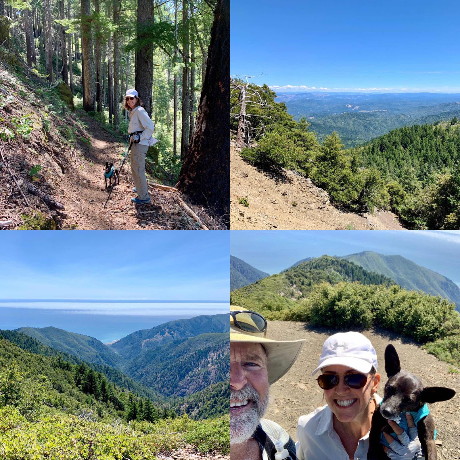
King Peak, in the King Range National Conservation Area, is a fun short hike. It’s a Cadillac of a trail with a steady grade and plenty of switchbacks. The lower sections are heavily shaded and the upper portions are low chaparral with great views. From the top there is a 360 degree view with the Pacific Ocean to the west and, on clear days, Mount Shasta to the east. There is even a small observation deck. Dogs on a leash are allowed, so it’s fun for your pup too.
Total mileage is 5.28 with a total elevation gain of 1953 feet. It is a partial loop trail. Going counterclockwise at the y, (right at Y , not to Maple Camp) it is only 1.95 miles to the top. You could turn around here and head back the same way you came, but we opted for the loop around the peak. We continued on the trail that quickly descends into Maple Camp. Here there was a small creek running and many flat spots for camping. There are numerous small trails to camping spots, so just stay on the trail closest to creek and it will sort itself out.
It took us a little less than three hours to hike and about and hour and half to drive from Redway, Ca. to the trailhead.
The drive is a big part of the adventure. In Redway take Redwood Drive onto the Briceland Thorn Road (towards Shelter Cove)and go about 10 miles. Turn right onto Ettersburg-Honeydew Road and go 11.7 miles; this road was labeled Wilder Ridge Road on google maps. Turn left onto graveled King Peak Road and go 2.9 miles. The last little bit of this road was rutted up when we went through and in our Subaru Outback, we had to drive carefully not to bottom out. Turn right onto what google maps labels King Range Road and go 6.5 mile to the end of the road and the Lightening Trailhead. On our return journey, we drove the King Range Road all the way back to Shelter Cove. (signage called this King Peak Road, and we noticed other differences between our gps and signs) It’s about 16 miles back to pavement. This graveled road has some spots that took some careful driving as well. It took us a little over an hour from the trailhead back to the pavement on the Shelter Cove Road.
The drive is a big part of the adventure. In Redway take Redwood Drive onto the Briceland Thorn Road (towards Shelter Cove)and go about 10 miles. Turn right onto Ettersburg-Honeydew Road and go 11.7 miles; this road was labeled Wilder Ridge Road on google maps. Turn left onto graveled King Peak Road and go 2.9 miles. The last little bit of this road was rutted up when we went through and in our Subaru Outback, we had to drive carefully not to bottom out. Turn right onto what google maps labels King Range Road and go 6.5 mile to the end of the road and the Lightening Trailhead. On our return journey, we drove the King Range Road all the way back to Shelter Cove. (signage called this King Peak Road, and we noticed other differences between our gps and signs) It’s about 16 miles back to pavement. This graveled road has some spots that took some careful driving as well. It took us a little over an hour from the trailhead back to the pavement on the Shelter Cove Road.
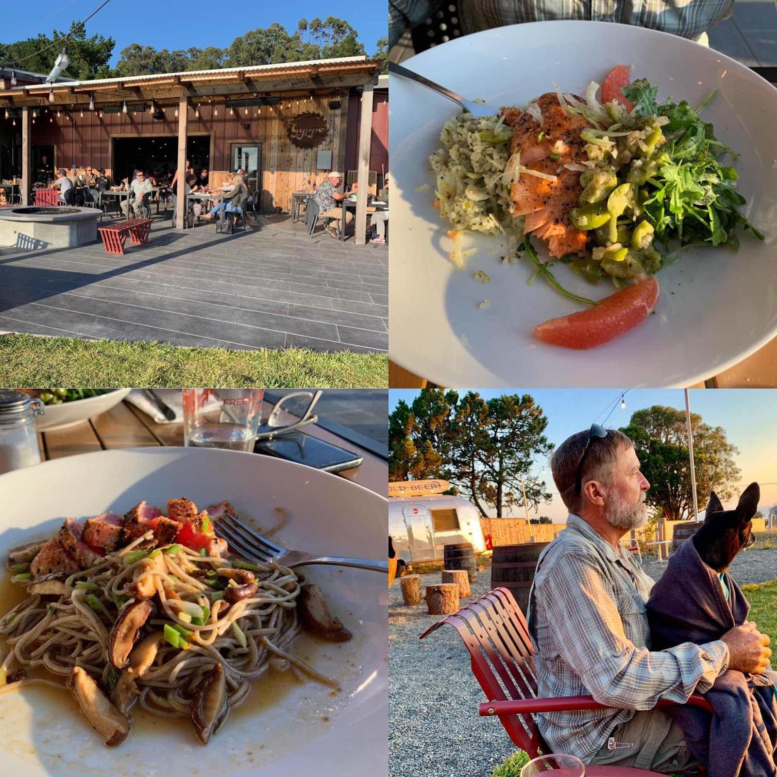
We had ulterior motives as we wanted to go the the Gyppo Ale Mill in Shelter Cove. They have ocean views, great beer, exquisite cuisine and it’s dog friendly. Check it out.
Comments
Post a Comment
We love your comments or questions. Have a great day and live a good life.