Day 12: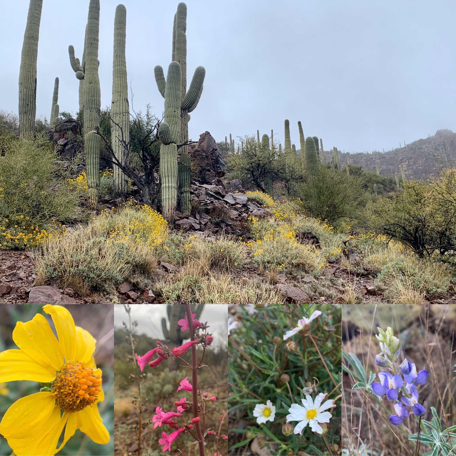
Near La Cienega Creek to Colossal Caves

Colossal Cave to Grassshack Camp

Grass shack campground over a mountain and down to Cattle Country
Stats:

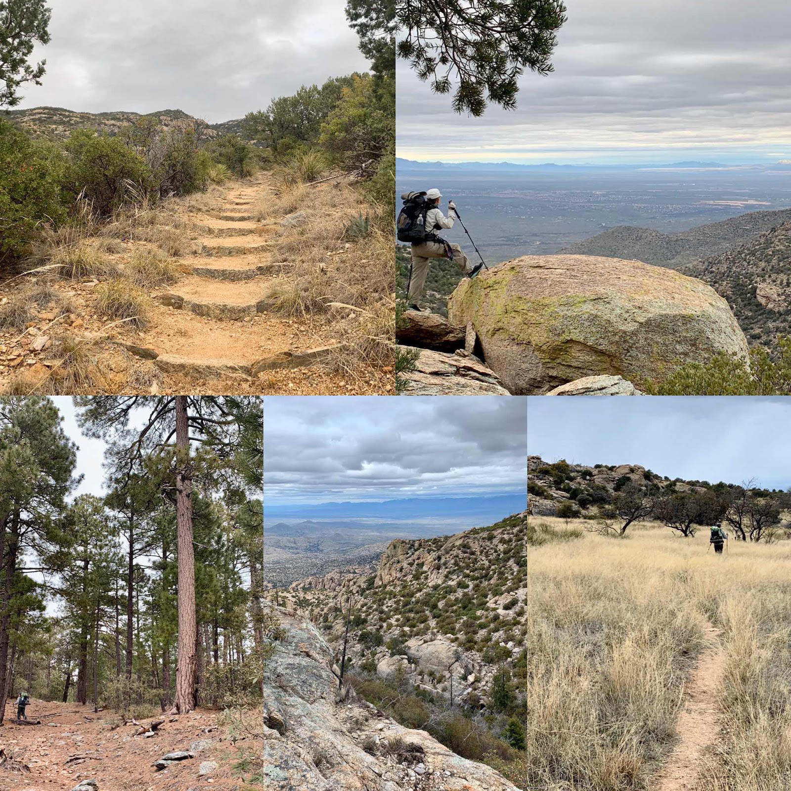
It was overcast all day and it made for great hiking weather. We awoke and chatted with a fellow grass shack camper named O Positive and then we headed up and up and up until we reached Manning Camp.


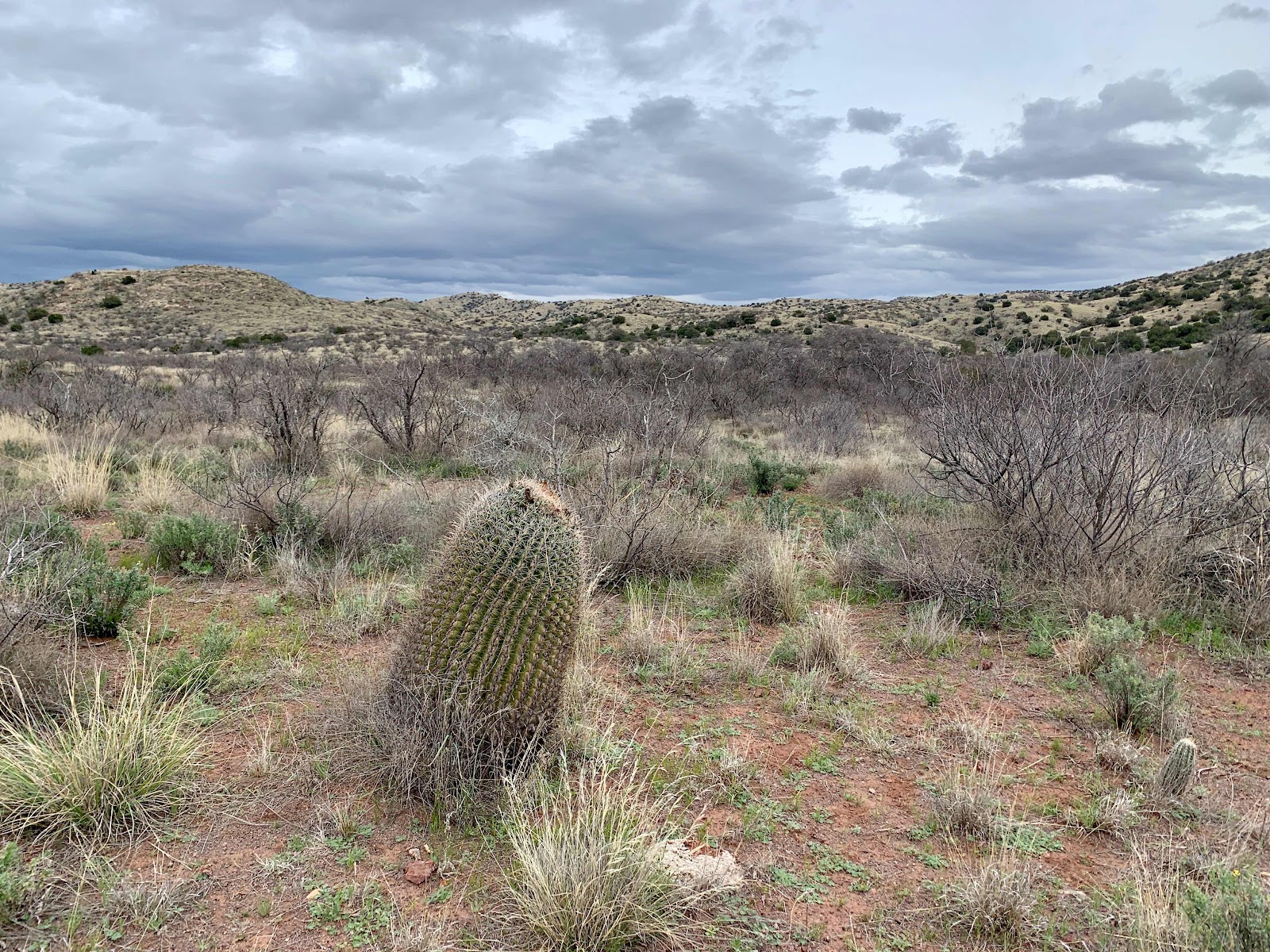
The trail soon began to descend. We went down, down, down back through all the 6 distinct biomes. A lot of the trail was right on the edge of a huge drop off and we, of course, had amazing views down to the sea of desert. I slipped on loose rock a couple times and fell. Minor bruises, thankfully, not over a cliff. I also got turned around today and thought north was south. Lol. Then I saw this barrel cactus and it re- oriented my brain because they almost always point to the south.

The mountain behind us is the one we climbed.

Cattle Country to Molino Campground

“For myself I hold no preferences among flowers, so long as they are wild, free, spontaneous.”- Edward Abbey

Foothills of Tucson
Near La Cienega Creek to Colossal Caves
AZT mile 119.6
Stats:
Stats:
Hiked 6.4 miles
Climbed 860 feet
We awoke to drizzle and the creosote bush released it’s aroma. Delightful! We soon hiked into the land of the mighty saguaro cactus. Some towered 40 or 50 feet above us. The Brittle bush with its bright yellow flowers brightened the trail as well. Many other flowers are blooming too. I snuck my camera out and took a few of their photos. It was worth the risk of water damage.
When we got to Colossal Caves they could not find the backpacking fuel that we sent via Amazon. Tracking said it was there, but they said it wasn’t. Rain/sleet and snow is in the forecast for the coming mountains and having the fuel is very important. Hot food and the possibility of making a hot water bottle could be life saving in regards to hypothermia. We ate a humongous plate of delicious frito nachos loaded with everything and discussed our options. I called a nearby trail angel hoping they might have fuel, they didn’t. We decided we needed to go to Tucson to get some fuel and I requested a ride through UBER. Right before our driver arrived the proprietor came out with our fuel and said it was just delivered. Ha. Not what my tracking said, but oh well. We decided to go ahead and take the UBER ride and go to Tucson and be dry. All of a sudden the idea appealed to us because as we sat there we got cold. So now we are in a Studio 6 and making plans for the next few days until the storm passes. We had been especially looking forward to this next section of hiking and would rather do it when the weather is nice and with visibility for the views. The trail isn’t going anywhere and currently we aren't either.
Ironically this is basically the same spot we got off trail due to my knee injury three years ago. It makes us nervous. Is some dark force conspiring against us? Of course not! But still...
Day 13:
Colossal Cave to Grassshack Camp
AZT mile 135.3
Stats:
16.3 miles on trail, plus 1.4 extra
3300 up 1200 down
We are camped at 5280 feet- a mile high
Woke up and checked the weather and saw that the storm was delayed, so we packed up and called Uber to take us back to the mountain. We are excited to be heading into the Rincon Mountains today. This will be our third sky island to climb. We think this trail will actually get us in better shape. Already Hawkeye has trimmed down and is getting stronger each day. I don’t notice any physical differences in myself yet.
By nine we were dropped off at Colossal Caves and began hiking again. It was a picture perfect day. We began in the lowlands full of a variety of cactus and wildflowers. My eyes feast on desert landscapes. I think it’s because it is so different than where we live in the redwoods of Northern California.
We pass Rincon Creek by noon. This is where we had to leave the trail due to my injury in 2017. Woohoo! We will be seeing new sights from here on out. We soon entered Saguaro National Park and saw lots and lots of Saguaros surrounded by the brilliant yellow brittle bush. It’s an outstanding sight. We only meet two day hikers out taking photos of wildflowers.
Our shoulders get sore because our packs are too heavy. I blame it on too much food, so I snacked and sweated all the way up the mountain. I devoured two snicker bars, two fig newtons, two jolly ranchers and a cup of trail mix. The views into the Tucson bowl were large and the red rocks, huge saguaros and hot sun brought to mind once again a Hollywood western.
The climb was pretty relentless and fully exposed to the sun. Big granite slabs and a creek invited Mark to cool off. I just soaked my feet. I was too tired to remove my clothes. Lol. We hiked into juniper and fox tail pines and our campsite for the night has a melodious, clear stream. I couldn’t find the tiki bar though. I was expecting one with a name like Grass shack campground.
A few of the cacti:
Day 14:
Grass shack campground over a mountain and down to Cattle Country
AZT mile: 150.3
Stats:
15 miles hiked
3500 feet climbed
4800 descended
Wow! It felt like we climbed to the top of the world today and then back down. According to the guidebook on our phone we went through 6 biotic communities.
It was overcast all day and it made for great hiking weather. We awoke and chatted with a fellow grass shack camper named O Positive and then we headed up and up and up until we reached Manning Camp.
Manning cabin was built in 1904 by a rancher and is now used by the national Park Service. We did not linger long as it was very cold. My toes actually got so cold that they felt like they were hot! Very soon we came to patches of snow on the north side of Mica mountain and we found some nice chunks of mica and saw a group of deer.
The trail soon began to descend. We went down, down, down back through all the 6 distinct biomes. A lot of the trail was right on the edge of a huge drop off and we, of course, had amazing views down to the sea of desert. I slipped on loose rock a couple times and fell. Minor bruises, thankfully, not over a cliff. I also got turned around today and thought north was south. Lol. Then I saw this barrel cactus and it re- oriented my brain because they almost always point to the south.
When we reached Tangue Verde canyon we soaked our feet and had a peaceful lunch time. Except for O Positive, we’ve seen no one all day and have enjoyed the solitude.
Now we are camped on ranch land and hear someone shooting. Black angus cattle graze around us and a soft rain falls on our tent. A lone coyote yips nearby.
The mountain behind us is the one we climbed.
Day 15:
Cattle Country to Molino Campground
AZT mile 161.6
Stats:
11.3 Miles
2100 feet climbed
1900 feet descended
We slept great last night and awoke to the pleasant aroma of wet desert grasses. The sun didn’t break through the clouds until about ten AM and we quickly laid out our gear to dry. A rancher on a quad drove by and waved. We’ve probably been hiking on his property since we left Saguaro National Park. The Arizona Trail is a designated national trail and has easements across private land. We’ve been really impressed with the trail and it’s pristine condition. We’ve seen no trash. We think this trail will become more popular and we hope that future users continue to be respectful.
Our youngest son sends us a text with a weather update and rain and snow is in the forecast. We begin discussing our options. I kind of want to hike on and Hawkeye thinks it is wise to go back down to Tucson. I throw out my proverbial fleece and pray- if someone is readily available for a ride at the highway we will be passing then I’ll take it as a sign that we should get off the trail.
We leave rolling the grasslands with its mesquite trees just starting to leaf out and head up into a red rock area. Cottonwoods are also leafing out along the creeks. It’s a steep climb brightened up by flowers. I love flowers and keep stopping to take their photo and Hawkeye pulls way ahead. He is really hiking strong today.
When I catch up at the highway he’s talking to a Tucson trail angel waiting for a different hiker. Scott, the angel, agrees to give us a ride to town (only 5 miles away)and he even has an apartment that he just moved out of for us to stay in. His lease is not quite up yet. There is a pizza place and a Whole Foods store right around the corner. Funnily enough, I hesitate to go down at first. Then I remember my prayer and walk through that open door and am now enjoying a great pizza and a Corona. Not to be confused with the Coronavirus that has the store’s shelves empty of hand sanitizer. We kind of use hand sanitizer a lot on the trail. Instead I guess I’ll pack out a little piece of soap. Crazy times.
“For myself I hold no preferences among flowers, so long as they are wild, free, spontaneous.”- Edward Abbey
Day 16:
Foothills of Tucson
Zero trail miles
We enjoy breakfast at Whole Foods and Hawkeye gets a haircut and beard shaping. We laze around all day with a great view of the Tucson area and surrounding mountains. Scott, the trail angel told us that Tucson is surrounded by the acronym of CHRIST:
Catalina Mountains, Huachuca Mountains, Rincon Mountains, Santa Rita Mountains and Tucson Mountains.
Comments
Post a Comment
We love your comments or questions. Have a great day and live a good life.